<< episode
Teacher Edition | View the Map
Week of December 22, 2024
Right click and SAVE AS
to download the Google Earth file for this episode
Use free Google Earth software
to OPEN it, using File> Open.
Find more tech info here.
Text Message from Pandora - U still in Africa? RUOK? Plz call sometime. Miss U
Text Message to Pandora - Yes - in Africa. We R ok. Call soon
We arrived in Madagascar last weekend. And we gave our sister Pandora a quick call. She was thrilled to hear from us. But, as usual, Pandora was trying to find out too much information. So we had to quickly get off the phone so she didn't learn too much about the case.
Madagascar is my favorite country so far (we attached some great pictures of Madagascar). This island nation is located off the southeastern coast of Africa in the beautiful waters of the Indian Ocean. It is the fourth largest island in the world. I wonder which island is the largest in the world? Meri read in a magazine that the country of Madagascar is about double the size of Arizona (our home state). Madagascar is rich in natural resources. These resources include coal, salt, hydropower, bauxite, chromite, graphite, quartz, tar sands, semiprecious stones, mica, and more. I wonder what all those things are used for? The agricultural products of Madagascar include vanilla, bananas, peanuts, beans, cocoa, rice, coffee, and sugarcane (among others). Meri and I learned today that Madagascar is the world's leading producer of vanilla. Madagascar accounts for more than half of the total world's vanilla exports. Thank goodness for Madagascar, or our ice cream would be tasteless!
Wow, talk about diversity! Madagascar is a "salad bowl" of various cultures, much like the United States. The main cultural influences include the Austronesian culture (a mix of Oceania, Australia, and Polynesia) and African culture. But there are also people from Arab, Indian, and European cultures (and numerous others). Madagascar is also known for its wide variety of wildlife. In fact, 5% of the world's animal and plant species live in Madagascar. Think about that for a minute. In a country that is only double the size of Arizona - you will find 5% of the world's animal and plant species! Most of these species (80%) are only found in Madagascar! One of the more popular species that are endemic to Madagascar (which means that it isn't found anywhere else in the world) is the lemur. We attached a cool picture of the lemur that we saw last weekend (check it out).
- Geo
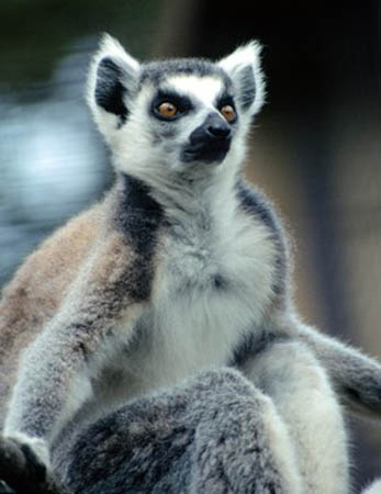
This is a picture of a lemur.
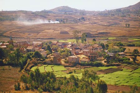
Here is a picture of the beautiful land of Madagascar.
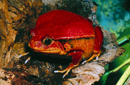
This is a frog (called the tomato frog), found in Madagascar. It kind of looks like a tomato!
Greatest Places: Madagascar
This interactive website is really neat. You can listen to a lemur call, watch a chameleon catch live food, and learn more about the unique island nation of Madagascar.
Lemurs Park
Visit the park virtually (and change to your chosen language).
We paid the driver and got out of the car to follow this oddly familiar-looking man. He was walking towards one of the large hotels in Antananarivo. Geo and I stayed back far enough to see him, but he didn't notice that we were following him.
Finally, we realized where we had seen him before. This man looked identical to the rude bodyguard that we encountered two weeks ago in Abuye, Ethiopia. How could this be?
We followed him into the hotel. As he headed towards the elevator, we heard one of the employees say, "Welcome back, Mr. V." Geo and I were positive this was the same man. But if he wasn't a bodyguard, who was he? And why wouldn't he allow us into Abuye?
Holy Idaho, did we ever get lucky? A few minutes later, the front desk clerk called and said, "Mr. V., we have you booked on the 4 p.m. flight to Cairo, Egypt, on January 5th." So, guess where Geo and I are heading soon! You guessed it--Egypt.
Cairo is Egypt's capital. We have to track down who Mr. V is exactly and how he is connected to the disappearance of Dewey, the Truth-sniffing Dog. Uncle GT texted us and said he wanted to meet us for a holiday break while in Cairo, too!
We are heading directly to the airport to try to catch a flight to Cairo. It will be nice to explore Cairo for a few weeks (especially with Uncle GT). We plan to be at the gate when Mr. V arrives on January 5. We plan to spend some time in Cairo with our uncle.
- Meri
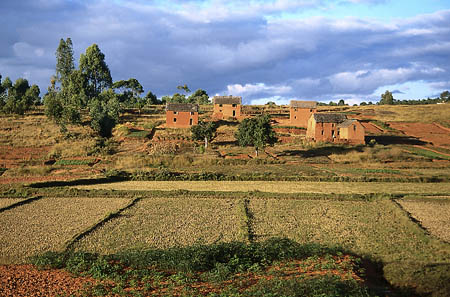
Another picture of Madagascar
Map of Africa
What cardinal direction do you travel going from Madagascar to Egypt? Which two large seas border Egypt? Are these large bodies on the eastern, western, northern, or southern coasts of Egypt? What famous canal is located near Egypt?
Meri also told me that Egypt has a famous peninsula (the Sinai Peninsula). A peninsula is a piece of land bordered by water on three or more sides but not an island. The Sinai Peninsula is a triangular-shaped peninsula that lies between the Mediterranean Sea (to the north) and the Red Sea (to the south). This peninsula also forms a land bridge to Southwest Asia. Check out our cool picture and map of the Sinai Peninsula. I wonder if this peninsula is as large as the Yucatan Peninsula in Mexico?
West of the Sinai Peninsula is the Suez Canal. This manmade canal is between Africa and Asia. It was opened in 1869 to allow two-way water transportation between Africa, Asia, and Europe. Do you remember learning about the Panama Canal while we were in South America? The Suez Canal was created for many of the same reasons (to move people and products quickly and safely between various continents). The Suez Canal is exactly 101 miles long (or 163 kilometers).
The world-famous Nile River also flows throughout Egypt (and other African countries). This river is the longest river in the world! Do you remember that the Amazon River (in South America) is the largest river in the world (by volume)? I know this sounds confusing. But it is pretty simple to explain. The Nile River is longer than the Amazon River. The Nile River is approximately 4,160 miles long, while the Amazon River is approximately 4,000 miles long. However, the Amazon River is the largest by volume because the Amazon River has more water. This could mean that the water is deeper in certain areas or the river itself is wider. The Nile River ends at a large delta that empties into the Mediterranean Sea. A river delta is the triangular piece of land (usually sand and soil) that is located at the mouth (or inlet) of a river where it meets salt water.
Our plane is about to land, and we must put away our laptops. Now we can explore EGYPT and decide what to do next week when "Mr. V" arrives in Cairo. We aren't exactly sure which gate he will be flying into. What do you think we should do to try to find "Mr. V" when he arrives in Cairo, Egypt, on January 5th?
- Geo
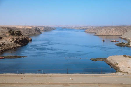
The beautiful Nile River
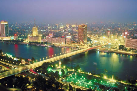
The Nile River by moon light
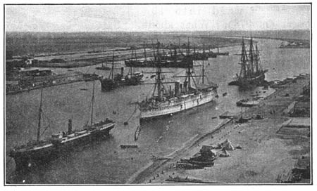
This drawing shows the Suez Canal.
Austronesian - a culture found in Madagascar and other areas throughout the world offering a unique mix of Oceania, Australia, and Polynesia cultures.
delta - the triangular piece of land (usually sand and soil) that is located at the mouth (or inlet) of a river where it meets salt water.
endemic - A species that is endemic, is not found naturally anywhere else in the world.
map coordinates - numbers that provide the exact location of a specified country or other area. The coordinates provide the degrees of longitude and latitude. Coordinates help people locate specific areas on a map.
natural resources - any substance that is made by nature and used to enhance the lives of living things. Some examples of natural resources include sunlight, minerals, soil, and water.
peninsula - a piece of land that is bordered by water (on three or more sides), but is not an island. A peninsula is attached to a larger body of land but sticks out into the water.
Suez Canal - The Suez Canal is a manmade canal between Africa and Asia. It was opened in 1869 to allow two-way water transportation between Africa, Asia, and Europe.
Back to topAdditional Web Resources:
Exploring Africa
Exploring Africa brings Africa into your classroom through numerous interdisciplinary lessons. There are 20 modules (within 4 general units of study). The general units include "Why Study Africa," "Studying Africa Through the Social Studies," "Studying Africa Through the Humanities," and "Regional Perspectives." Each module contains a teacher version that includes objectives, focus questions, activities, background information, and more.
The Africa Guide
This website provides a colorful interactive map of Africa. Users are able to click on any country in Africa to learn more about that particular country.
Grade 3-5: Knows the basic elements of maps and globes (title, legend, cardinal, scale, grid, meridians, time zones, etc.).
Grade 3-5: Uses map grids (e.g., latitude and longitude or alphanumeric system) to plot absolute location.
Grade 3-5: Knows major physical and human features of places as they are represented on maps and globes. Knows how to read different maps: road, relief, globe, etc..
Grade 3-5: Knows the approximate location of major continents, mountain ranges, and bodies of water on Earth.
Grade 6-8: Knows the location of physical and human features on maps and globes (e.g., culture hearths such as Mesopotamia, Huang Ho, the Yucatan Peninsula, the Nile Valley; major ocean currents; wind patterns; land forms; climate regions).
Grade 3-5: Understands how changing transportation and communication technology has affected relationships between locations. Ease of travel between some and difficulty getting to some others because of transportation and how people move and shop from one to the other because of the ease (trains, road systems, ferries, etc...).
Grade 3-5: Knows different methods to measure data (miles, kilometers, time, etc..).
Grade 6-8: Understands distributions of physical and human occurrences with respect to spatial patterns, arrangements, and associations (e.g. why some areas are more densely settled than others).
Grade 6-8: Knows the physical characteristics of places (soil, vegetation, wildlife, etc..).
Grade 6-8: Understands criteria that give a region identity (such as Amsterdam as a transportation center or the Sunbelt's warm climate and popularity with retired people).
Grade 3-5: Knows significant historical achievements of various cultures of the world (e.g., the Hanging Gardens or Babylon, the Taj Mahal in India, pyramids in Egypt, temples in ancient Greece, bridges and aqueducts in ancient Rome).
Grade 3-5: Knows plants and animals associated with various vegetation and climatic region on Earth (i.e. kinds of plants and animals found in the rainforests of Africa).
Grade 6-8: Understands the symbolic importance of capital cities (such as Canberra, a planned city, as the capital of Australia).