Teacher Edition | View the Map
Week of February 5, 2023
Right click and SAVE AS
to download the Google Earth file for this episode
Use free Google Earth software
to OPEN it, using File> Open.
Find more tech info here.
We are currently 21st in line for take-off! Holy Idaho! How long will that take? At least it gives us more time to stay connected to our data plan and research Asia. Asia is a fascinating and HUMONGOUS continent. In fact, Asia is the largest continent in the world - but it is also the most populated continent in the world! Holy Idaho! I wonder how many people live in Asian countries. Geo researched and found out more information. First, the overall size of the continent equals about 30% of the land area of the entire world. Holy Idaho! Can you believe that? Second, the population is more than four billion people. Over 60% of the entire world's population lives in Asia. Wow, I thought that the United States had a lot of people! The total population of the United States is about 332 million. Holy Idaho! We don't even have nearly half as many people in the USA as in Asia.
We have attached a map of Asia, so you can see exactly where we are going. This continent is located mainly in the northern hemisphere and eastern hemisphere. But since it is so huge, there are also small parts of Asia in the southern hemisphere and western hemisphere. Do you remember what a hemisphere is? Hemisphere means half of a sphere. The northern hemisphere and southern hemisphere are divided by the equator (land and water north of the equator is in the northern hemisphere, and any land or water south of the equator is in the southern hemisphere). The eastern hemisphere and western hemisphere are divided by the prime meridian (the imaginary line that runs up and down a map or globe). All land and water east of the prime meridian is in the eastern hemisphere. While land and water west of the prime meridian is in the western hemisphere.
Asia is often referred to as a part of Eurasia (the giant land mass that encompasses Europe and Asia). Asia occupies much of Eurasia, while the western side of the land mass is the continent of Europe. Off of the eastern coast of Asia is the International Dateline. This is kind of confusing. The International Dateline is an imaginary line of longitude (our map shows it) on the surface of the Earth. It is on the opposite side of the world than the Prime Meridian. Here is the confusing part - when someone crosses this imaginary line, it results in a day or 24 hours being added or subtracted. If you head east leaving Asia and fly over the International Dateline, you subtract 24 hours. So if it was 6 pm on Friday night and we flew over the International Dateline heading east, it would now be 6 pm on Thursday night! Holy Idaho - isn't that wild? And then the opposite reaction happens when you fly west over the International Dateline you add 24 hours. So instead of being 6 pm on Friday night, it is now 6 pm on Saturday night - that means a day actually "disappears" out of my life --- or I get to live the same day twice! I will go speak to one of the airline employees and see when we will take off - it has been over 2-hours now.
- Meri
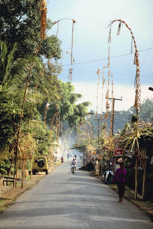
This picture shows one of the beautiful towns in Indonesia.
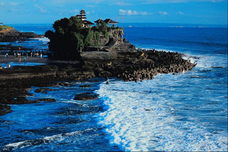
Here is a picture of Bali - a tropical tourist location in Indonesia. I dream of going to Bali!!
Map of Asia
Take a look at the attached map to see the amazing continent of Asia (the grey areas represent Asia). Can you find Russia? Japan? China? Pakistan? Korea? Indonesia? Can you find the International Dateline?
Time Zone Converter
Here is a link to a time zone converter. Check it out. Try the time zone converter to see different times RIGHT NOW in Indonesia, Russia, Japan, China, and where you live.
Text Message From Pandora - wayn? ru2ok?
Text Message To Pandora - On plane
Text Message From Pandora - 2 where?
Text Message to Pandora - Will call 2nite
Text Message From Pandora - 2 where?
Text Message to Pandora - Can't cuz secret. bbfn
- Geo
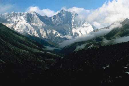
Mt. Everest - WOW!!
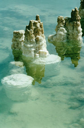
The Dead Sea (the white formations are salt and mineral deposits)
Airpano
Take a virtual tour of Mount Everest. Holy Idaho - so cool!!
Map of Asia
Can you locate the country we are flying to? OR WAITING to fly to? What other countries will we be near?
The weather here is very hot and humid since we are so close to the equator. The map coordinates for Indonesia are 5 00 South and 120 00 East. Since 0 degrees latitude represents the equator and Indonesia is at 5 00 South, we are VERY close to the equator - and boy, can we feel the heat! Indonesia experiences many natural hazards including earthquakes, volcanoes (Indonesia is also near the Ring of Fire), occasional floods, forest fires, severe droughts, and even tsunamis!
Indonesia is blessed with many natural resources, including tin, petroleum, natural gas, timber, nickel, copper, coal, silver, gold, fertile soils, and more. Over 11% of the land here is arable. Do you remember what arable means? Some of the leading agricultural products include rice, eggs, pork, beef, poultry, palm oil, copra, coffee, cocoa, rubber, and peanuts, among others.
The people in Indonesia work in various industries, including tourism, food, plywood, chemical fertilizers, petroleum, natural gasses, rubber, footwear, and many others. I would like to know if any of my shoes were made in Indonesia. The main exports of Indonesia include electrical appliances, oil and gas, textiles, rubber, and plywood. They are exported to countries all over the world, including Japan, China, and even the United States! Do you remember what the term exported means?
Geo and I are heading out "on the town" now. Veritas Resources is closed until Monday. So we will post again after we visit the company.
- Meri

Here is a picture of the busy city.
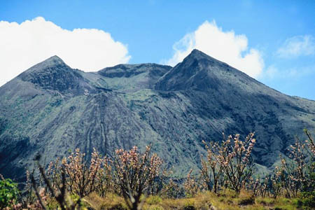
Mount Bator - a popular volcano (and tourist attraction) in Indonesia
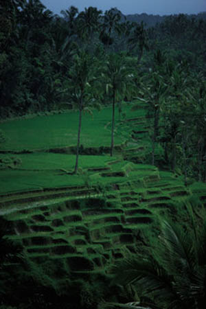
Rice paddies I saw in Indonesia
VISITING THE MONAS TOWER JAKARTA: Indonesia landmark (vlog)
This is a really cool video about Jakarta and the Monas Tower. Take a look and you will feel like you are there yourself!
- Geo
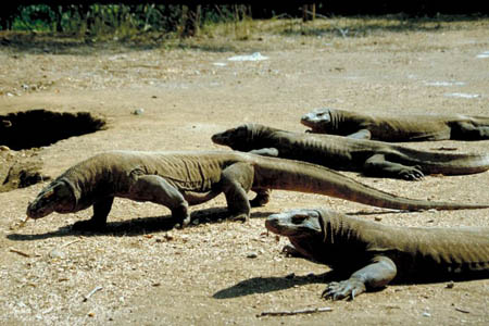
Here is a picture we found of varanus komodensis (AKA - komodo dragons). Yikes, glad we didn't see any upclose!
Map of Asia
Can you look at the attached map and tell us what cardinal direction we will be traveling to go from Indonesia to Hong Kong?
arable - land that can be used to grow crops.
cardinal direction - a term used to describe all four primary directions (north, south, east and west).
earthquakes - shaking and vibration on the surface of the earth. Earthquakes can be a result of underground movement along a fault plane or from volcanic activity.
eastern hemisphere - all land and water east of the prime meridian.
equator - an imaginary line on the earth's surface that is positioned halfway between the north pole and the south pole. The equator divides the earth into the northern hemisphere and the southern hemisphere.
Eurasia - the giant land mass that encompasses parts of Europe and Asia.
exported - when a crop (or another product) is sent or transported to another country (for money).
hemisphere - half of a sphere.
International Dateline - an imaginary line of longitude, that is located on the opposite side of the world as the Prime Meridian. When you cross the International Dateline heading east, you subtract 24-hours. When you head west, you add 24-hours.
latitude - the lines that run across (east and west) a map. Lines of latitude measure degrees via north or south. The equator is at 0 degrees latitude.
longitude - lines that run up and down the map (north and south). These lines are used to measure degrees east or west from the prime meridian. The prime meridian is located at 0 degrees longitude.
map coordinates - numbers that provide the exact location of a specified country or other area. The coordinates provide the degrees of longitude and latitude. Coordinates help people locate specific areas on a map.
Natural hazards - extreme weather and/or other conditions caused by nature. Some examples include volcanoes, earthquakes, blizzards, tornadoes, droughts, tsunamis, and typhoons.
natural resources - any substance that is made by nature and used to enhance the lives of living things. Some examples of natural resources include sunlight, minerals, soil, and water.
northern hemisphere - the half of the planet Earth that is north of the equator. The northern hemisphere contains 90% of the human population and most of the land on the Earth.
Northwest Passage - a shortcut between the Atlantic and Pacific Oceans through the Canadian Arctic. This passage is a direct route for ships to travel from Europe to Asia across the Arctic Ocean. The passage is becoming ice-free for the first time since satellite records began to be kept in the 1970s.
prime meridian - the imaginary line that runs up and down a map or globe. It is found at 0 degrees longitude. This imaginary line runs vertically through the United Kingdom, France, Spain, western Africa, and Antarctica. The prime meridian divides the world into the eastern hemisphere and western hemisphere.
ring of fire - a circle that encompasses the Pacific Ocean. In that circle, many volcanic eruptions and earthquakes occur. There are over 450 volcanoes in the ring of fire. Sometimes even tsunamis occur in the ring of fire.
southern hemisphere - the half of the planet Earth that is south of the equator. The southern hemisphere contains all of Antarctica and Australia, most of South America, and part of Asia and Africa.
tsunamis - an enormous ocean wave that is produced by a landslide, volcanic eruption, or a sub-marine earthquake.
western hemisphere - all land and water west of the prime meridian.
Back to top
Grade 3-5: Knows the basic elements of maps and globes (title, legend, cardinal, scale, grid, meridians, time zones, etc.).
Grade 3-5: Uses map grids (e.g., latitude and longitude or alphanumeric system) to plot absolute location.
Grade 3-5: Knows major physical and human features of places as they are represented on maps and globes. Knows how to read different maps: road, relief, globe, etc..
Grade 3-5: Knows the approximate location of major continents, mountain ranges, and bodies of water on Earth.
Grade 3-5: Understands how changing transportation and communication technology has affected relationships between locations. Ease of travel between some and difficulty getting to some others because of transportation and how people move and shop from one to the other because of the ease (trains, road systems, ferries, etc...).
Grade 6-8: Understands distributions of physical and human occurrences with respect to spatial patterns, arrangements, and associations (e.g. why some areas are more densely settled than others).
Grade 6-8: Knows the human characteristics of places (e.g., cultural characteristics such as religion, language, politics, technology, family structure, gender; population characteristics; land uses; levels of development).
Grade 6-8: Knows the physical characteristics of places (soil, vegetation, wildlife, etc..).
Grade 3-5: Knows the characteristics of a variety of regions (climate, housing, religion, language, etc..).
Grade 6-8: Understands criteria that give a region identity (such as Amsterdam as a transportation center or the Sunbelt's warm climate and popularity with retired people).
Grade 3-5: Knows the physical components of Earth's atmosphere (weather and climate), lithosphere (land forms such as mountains), hydrosphere (oceans, lakes and rivers), and biosphere (vegetation and biomes).
Grade 3-5: Knows how Earth's position relative to the Sun affects events and conditions on Earth.
Grade 6-8: Understands the symbolic importance of capital cities (such as Canberra, a planned city, as the capital of Australia).
Grade 3-5: Knows how humans adapt to variations in the physical environment (e.g. choices of clothing, housing styles, agricultural practices, recreational activities, food, daily and seasonal patterns of life).
Grade 3-5: Knows how communities benefit from the physical environment (e.g., people make their living by farming on fertile land, fishing in local water, working in mines; the community is a port located on a natural harbor, a tourist center located in a scenic or historic area, an industrial center with good access to natural resources).
Grade 3-5: Knows natural hazards that occur in the physical environment (floods, tornadoes, earthquakes, etc..).