Teacher Edition | View the Map
Week of October 27, 2024
Right click and SAVE AS
to download the Google Earth file for this episode
Use free Google Earth software
to OPEN it, using File> Open.
Find more tech info here.
- Geo
Map of Canada
Take a look at the map, can you find Vancouver? Can you find the National Capital? If you are having trouble, it is located in the province of Ontario. Okay, here is another one for you geography experts; can you find the capital of Manitoba?
If you guessed Winnipeg you are on the road to Geography stardom - lol.
Vancouver, British Columbia, Canada - Virtual Tour
View this short and engaging tour of Vancouver.
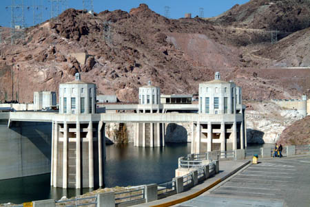
Right this very moment, we are flying over Las Vegas. Our plane took off, and we could immediately see the lights. Even though it is 10 pm and dark outside, the city is all lit up. Las Vegas is the most populated city in the state of Nevada. Las Vegas is known worldwide as a top tourist attraction offering casinos, wonderful entertainment, and a fun family vacation destination. Las Vegas is actually located in a desert - the Mohave Desert. It is amazing that there is such a busy city in the middle of a desert! Geo didn't understand how a big city could be built in the middle of a desert. I explained to him that it was all thanks to the Hoover Dam (see my picture of the Hoover Dam below). A dam is basically a wall that is built to hold back the water of a creek, stream, or river. A dam may also be used to generate hydroelectric power, for flood control, to provide a water supply to towns and cities, and even to create recreational areas or habitats for wildlife. Did you know that the Hoover Dam is at a historic low due to the drought? It is pretty extreme! The Hoover Dam was built during the Great Depression (1931-1935) when people were desperate for work and were willing to travel to the canyon near Las Vegas to earn money for their families. These brave people faced extreme heat, choking dust, and dangerous heights - all so that electricity and water could be brought to millions of people across the southwest. Having water available in the middle of the desert made it possible for big cities like Las Vegas to grow there.
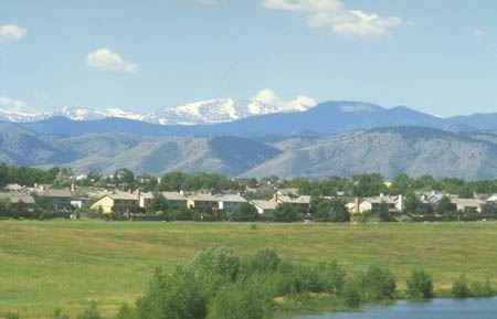
Up here on the plane, we have a gorgeous view of the Rocky Mountains just west of Denver. Did you know that the Rocky Mountains stretch from Canada all the way down to New Mexico? Although we couldn't land this plane and take our own picture, Uncle GT shared a photo of Denver (and the Rocky Mountains). We included the picture at the end of this journal entry. One surprising fact that I learned about Denver is that the city has over 300 days of sunshine during the year. Wow, that is surely different than the 175+ days of rain in Seattle each year. Did you know that Denver was nicknamed the Mile-High City? This is because the city's elevation is exactly a mile (5,280 feet or about 1,609 meters) above the sea. I wonder if there are any cities in the world higher than Denver? Okay, we are getting ready to land.
- Meri

The Hoover Dam

The Rocky Mountains
LAS VEGAS STRIP AT NIGHT, Nevada, USA
Even at 10 pm at night, this city is busy and full of lights.
Virtual Reality Tour of the Hoover Dam
Check out this interactive tour of the Hoover Dam.
Uncle GT just got a phone call. Claude Equator tried to purchase an airline ticket from Chicago to DC. It turns out that Claude Equator didn't fly into the Chicago O'Hare Airport. There is a second fairly large airport in Chicago: Chicago Midway International Airport. I should have done better research. Uncle GT told us that Claude flew to Chicago and the airline. I assumed he meant Chicago O'Hare Airport, and when I reread his text, he even told me the abbreviation for the airport was MDW (which is the Midway abbreviation). One thing I learned the hard way today... details matter! Anyway, since Claude's name was now on the government's "wanted" list, he was stopped at the Chicago Midway airport. Claude was extremely confused because he was traveling with a dog - but the dog wasn't Dewey (but rather a labradoodle - half Labrador retriever and half poodle). So, we thought we were at a dead end - until Uncle GT got a text message from an unknown number.
Text Message to Agent GT: TWIMC - I have Dewey. We r in Mexico - gl finding us. Hehehe. YDKM - Dewey is OK. GGN - Ms. E.
Uncle GT had to return immediately to Washington, D.C., for impending business. So Meri and I are on our own investigating the case in Mexico. We have to find Ms. E. and Dewey. But where do we begin?
There are three important locations in Mexico for us to investigate - Mexico City, the Caribbean Coast, and the Mayan Ruins on the Yucatan Peninsula. So, where do we begin?
- Geo

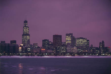
Chicago (Lake Michigan and the Willis/Sears Tower)
Skydeck Chicago Virtual Tour
Learn more about Willis Tower and view the city.
cardinal direction - a term used to describe all four primary directions (north, south, east and west).
dam - a wall that is built to hold back the water of a creek, stream, or river. Dams may also be used to generate hydroelectric power, to provide water supply to a town or city, to control flooding, or to create recreational areas or habitats for wildlife.
legend - another term for a key on a map. It explains the symbols used in the map. The legend may include a map scale, origin, and other information about the map.
provinces - a name for a secondary level of government (secondary to the country itself). A province is similar to a state (such as Arizona or Texas).
scale - shows the relationship between the distance on a map and the corresponding distance on the earth. For example, 1 inch may equal 500 miles. This allows users to calculate the approximate distance between two locations on a map.
territories - similar to a state (such as Arizona or Texas). Territories are land areas under the jurisdiction of a government.
Back to top
Grade 3-5: Knows the basic elements of maps and globes (title, legend, cardinal, scale, grid, meridians, time zones, etc.).
Grade 3-5: Knows major physical and human features of places as they are represented on maps and globes. Knows how to read different maps: road, relief, globe, etc..
Grade 3-5: Knows the location of major cities in North America.
Grade 3-5: Knows the approximate location of major continents, mountain ranges, and bodies of water on Earth.
Grade 6-8: Knows the relative location of, size of, and distances between places.
Grade 3-5: Knows different methods to measure data (miles, kilometers, time, etc..).
Grade 6-8: Understands distributions of physical and human occurrences with respect to spatial patterns, arrangements, and associations (e.g. why some areas are more densely settled than others).
Grade 6-8: Knows the human characteristics of places (e.g., cultural characteristics such as religion, language, politics, technology, family structure, gender; population characteristics; land uses; levels of development).
Grade 3-5: Knows the characteristics of a variety of regions (climate, housing, religion, language, etc..).
Grade 6-8: Understands criteria that give a region identity (such as Amsterdam as a transportation center or the Sunbelt's warm climate and popularity with retired people).
Grade 6-8: Knows how places and regions serve as cultural symbols (Opera House in Sydney or Tower Bridge in London).
Grade 3-5: Knows the physical components of Earth's atmosphere (weather and climate), lithosphere (land forms such as mountains), hydrosphere (oceans, lakes and rivers), and biosphere (vegetation and biomes).
Grade 3-5: Knows significant historical achievements of various cultures of the world (e.g., the Hanging Gardens or Babylon, the Taj Mahal in India, pyramids in Egypt, temples in ancient Greece, bridges and aqueducts in ancient Rome).
Grade 3-5: Knows how and why people divide Earth's surface into political and/or economic units (e.g., states in the United States and Mexico; provinces in Canada; countries in North and South America; countries linked in cooperative relationships, such as the European Union).
Grade 6-8: Understands the symbolic importance of capital cities (such as Canberra, a planned city, as the capital of Australia).
Grade 3-5: Knows how communities benefit from the physical environment (e.g., people make their living by farming on fertile land, fishing in local water, working in mines; the community is a port located on a natural harbor, a tourist center located in a scenic or historic area, an industrial center with good access to natural resources).
Grade 6-8: Knows the location of physical and human features on maps and globes (e.g., culture hearths such as Mesopotamia, Huang Ho, the Yucatan Peninsula, the Nile Valley; major ocean currents; wind patterns; land forms; climate regions).