<< episode
Teacher Edition | View the Map
Week of November 3, 2024
Right click and SAVE AS
to download the Google Earth file for this episode
Use free Google Earth software
to OPEN it, using File> Open.
Find more tech info here.
Text Message to Agent GT: I have Dewey. We r in Mexico - gl finding us. Hehehe. YDKM - Dewey is OK. GGN - Ms. E.
We weren't sure where to begin our search, so we asked you in our last blog post to help us to decide. Most of our readers said we should begin in Mexico City. I think you all were wise to start our investigation in Mexico City since it is the capital and a very busy city. During our journey, Geo and I studied maps of Mexico and did some research about the country. I never realized how large the country of Mexico is! It is 2,000,000 square kilometers. It would take about 8 million children lying down from head to toe to cover the perimeter of this large country. The official language spoken is Spanish. An astonishing 89% of Mexican residents are Roman Catholic. Holy Idaho! If you want to purchase something in Mexico, you don't use dollars but instead, use Mexican Pesos. The climate of Mexico varies from tropical to desert. The coast and lowlands are hot and humid for 12 months of the year. The interior highlands are milder and drier but do get cooler in the winter months.
Mexico has two large bodies of water that surround most of the country. Can you look at the map (I posted the link below) and figure out what the two large bodies of water are? On the eastern coast, you will find the beautiful Gulf of Mexico. On the western coast, you will find the equally breathtaking Pacific Ocean. A small part of Mexico (called the Yucatan Peninsula) is also bordered by another large body of water - the Caribbean Sea. Can you find Phoenix on this map? Holy Idaho! I never realized that I lived so close to Mexico.
- Meri
Map including Phoenix and Mexico
Can you find Phoenix on this map? What cardinal direction would you travel to go from Phoenix to Mexico? Does this map include a scale? If so, about how many miles are between Phoenix and Mexico?
Virtual Tour of Mexico City
Take a virtual tour of Mexico City and visit about ten famous locations.
- Geo

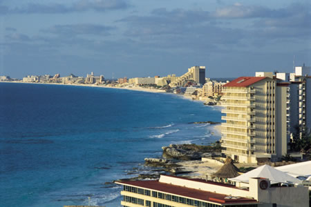
The view of Cancun from our hotel balcony!

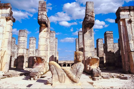
Chichen Itza - the largest of the Mayan Ruins
Visit Chichen Itza - Virtually
This virtual tour offers many video clips about the ruins.
Pandora to us: RUOK? WAYN - Mexico? Saw your blog post photo. U2 at the beach?
Us to Pandora: Yes, in Mexico. TTYL
- Geo
Text Message from Uncle GT: HT - have news on Dewey. Head to the cap. of Guatemala ASAP.
So what is the capital city of Guatemala? Geo figured that out quickly - the capital city of Guatemala is Guatemala City. I did some research about Guatemala during our flight. Did you know Guatemala has active volcanoes, Mayan ruins, and even earthquakes? Wow, this is one busy country.
Okay - you are not going to believe what happened! As we pulled up to our hotel, we saw another taxi drive by us. Guess who was in that taxi - a dog with a striking resemblance to Dewey, and he was with a woman in some sort of uniform! About 5-minutes later, we received a phone call on our cell from an unknown number. The female caller said, "I know that you two geography sleuths saw Dewey. We are on our way out of the city and heading to the ocean waves. Stop following us - Dewey is in no danger. He is necessary for our current project. GO BACK HOME." And then she hung up the phone.
Holy Idaho! The first thing we did was called Uncle GT. He said to travel west towards the coast. He had reason to believe they are heading to South America. We are taking a cruise; I can't wait - I have never been aboard a ship. The ship stops at several ports, but Uncle GT has told us that he believes that Dewey could only be heading to Brazil, Argentina, or Chile based on some research from his department. Which one should we investigate first?
We need your help - where should our investigation in South America begin?
- Meri
Guatemala City Walking Tour
Take a walking tour around Guatemala City.
Map of Central America and South America
Use this map to help us to decide where to go next.
cardinal direction - a term used to describe all four primary directions (north, south, east and west).
peninsula - a piece of land that is bordered by water (on three or more sides), but is not an island. A peninsula is attached to a larger body of land but sticks out into the water.
scale - shows the relationship between the distance on a map and the corresponding distance on the earth. For example, 1 inch may equal 500 miles. This allows users to calculate the approximate distance between two locations on a map.
Back to topAdditional Web Resources:
Travel for Kids - Mexico
This website is another great site for kids! The website includes a book list of stories that are purposeful to read to your students all about Mexico.
Grade 3-5: Knows the basic elements of maps and globes (title, legend, cardinal, scale, grid, meridians, time zones, etc.).
Grade 3-5: Knows major physical and human features of places as they are represented on maps and globes. Knows how to read different maps: road, relief, globe, etc..
Grade 3-5: Knows the location of major cities in North America.
Grade 3-5: Knows the approximate location of major continents, mountain ranges, and bodies of water on Earth.
Grade 6-8: Knows the location of physical and human features on maps and globes (e.g., culture hearths such as Mesopotamia, Huang Ho, the Yucatan Peninsula, the Nile Valley; major ocean currents; wind patterns; land forms; climate regions).
Grade 6-8: Knows the relative location of, size of, and distances between places.
Grade 3-5: Knows different methods to measure data (miles, kilometers, time, etc..).
Grade 6-8: Knows the human characteristics of places (e.g., cultural characteristics such as religion, language, politics, technology, family structure, gender; population characteristics; land uses; levels of development).
Grade 3-5: Knows the characteristics of a variety of regions (climate, housing, religion, language, etc..).
Grade 6-8: Understands criteria that give a region identity (such as Amsterdam as a transportation center or the Sunbelt's warm climate and popularity with retired people).
Grade 6-8: Knows how places and regions serve as cultural symbols (Opera House in Sydney or Tower Bridge in London).
Grade 3-5: Knows the physical components of Earth's atmosphere (weather and climate), lithosphere (land forms such as mountains), hydrosphere (oceans, lakes and rivers), and biosphere (vegetation and biomes).
Grade 3-5: Knows significant historical achievements of various cultures of the world (e.g., the Hanging Gardens or Babylon, the Taj Mahal in India, pyramids in Egypt, temples in ancient Greece, bridges and aqueducts in ancient Rome).
Grade 6-8: Understands the symbolic importance of capital cities (such as Canberra, a planned city, as the capital of Australia).
Grade 3-5: Knows natural hazards that occur in the physical environment (floods, tornadoes, earthquakes, etc..).