Teacher Edition | View the Map
Week of November 10, 2024
Right click and SAVE AS
to download the Google Earth file for this episode
Use free Google Earth software
to OPEN it, using File> Open.
Find more tech info here.
The Panama Canal is a waterway that connects the Atlantic and Pacific oceans. It is about 80 kilometers long (which is about 50 miles). This waterway is unique because it was cut through the isthmus that joins North and South America. An isthmus is a narrow strip connecting two larger bodies of land. The canal uses this cool system of compartments with entrance and exit gates called locks (below, I posted a neat interactive video showing this system - check it out). Holy Idaho! It is so cool how big ships can sail through that canal. The United States built the Panama Canal in the early 1900s and turned it over to Panama in 1999. The canal was officially opened in 1914. I wonder why the United States wanted to build the Panama Canal. Based on my research, there were several reasons why the canal was constructed. First, the Panama Canal helped to increase international shipping. Holy Idaho! Every year over 14,000 ships pass through the Panama Canal. Second, ships traveling from New York City, New York, to San Francisco, California, could arrive in half of the time thanks to the Panama Canal. Third, before the Panama Canal was created, anyone who wanted to sail around South America had to sail through the Drake Passage at Cape Horn.
Cape Horn is the bottom tip of South America. Geo was so glad that we didn't have to sail that far (since we are disembarking in Chile). I wonder why Geo didn't want to go that way. Holy Idaho! Based on my research, I discovered that the Drake Passage at Cape Horn has some of the roughest seas in the world! Now I know why Geo was glad that we didn't have to sail that far. That would have been one rocky ship.
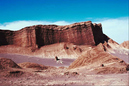
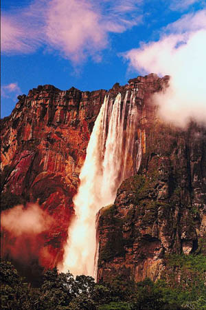
We are going to San Antonio, Chile (not Texas - hehe). During our journey, we noticed that South America has very diverse landforms - there are beaches, rainforests, deserts, and mountains (some with snow). This continent also has some really cool features. The largest river in the world (by volume), the Amazon River, is located in South America. The world's highest waterfall, Angel Falls, is located in the country of Venezuela (see the picture below. It is gorgeous). The world's longest mountain range, the Andes Mountains, is located in South America. The Andes are 7,000 kilometers long (4,400 miles). Do you realize how long that is? To go across the entire United States (from the clear western tip of California to Washington, D.C.) is about two-thirds of that length. Holy Idaho - that is a huge mountain range! South America is also the home to the world's driest desert, the Atacama Desert (check out our picture: very cool rock formation), and the world's largest rainforest, the Amazon Rainforest. Bolivia (one of the countries in South America) has the highest capital city in the world - La Paz. This capital city reaches a height of 3,600 meters (11,811 feet). Holy Idaho! That is even higher than the "Mile-High City" of Denver, Colorado, and the highest city in North America - Mexico City! I can't wait to get off of this ship and start exploring.
No news from Uncle GT yet. He sent us a few emails to ensure we were alright, but he hasn't received any phone calls, texts, emails, or other leads from the mysterious woman. Our cell phones don't have reception on this ship. It is great because Pandora can't reach us - hehehe. But, it is not so great because Dewey's capturers can't reach us either. Once we get onshore, we can check our text messages and voicemails. PS - check out the attached map of South America.
- Meri

The Atacama Desert (the world's driest desert)

Angel Falls (the world's highest waterfall)
Map of South America
Take a look at the map of South America. Can you find the Andes Mountains? Are they on the eastern or western side of the continent? In which countries are they found?
Hybrid Map of the Panama Canal
Be sure to click on the + to zoom in on the map. Can you find the two oceans that the Panama Canal connects? What oceans are they?
How Does The Panama Canal Work?
Check out this cool video about the Panama Canal.
Text Message from Pandora: RUOK? Text me ASAP. U in S. Amer. now? R U near the equator?
Text Message to Pandora: HT. ABT2 arrive in San Antonio, Chile. Yes, the equator goes through S. Amer. BBFN.
The equator is an imaginary line on the earth's surface that is directly positioned between the north pole and the south pole. The equator divides the earth into the Northern Hemisphere and the Southern Hemisphere. The Northern Hemisphere is the half of the planet Earth that is north of the equator. The Northern Hemisphere contains 90% of the human population and most of the land on the Earth. The Southern Hemisphere is the half of the planet Earth that is south of the equator. The Southern Hemisphere contains all of Antarctica and Australia, most of South America, and parts of Asia and Africa. Look at the map of South America - can you find the line representing the equator? This imaginary line runs through three South American countries (Brazil, Ecuador, and Colombia). There are many other lines on the map also. I wonder what they all mean? Okay, we can finally disembark our ship and head to our hotel. We will add more to our blog ASAP.
- Geo
Map of South America
Look at the map of South America. Can you find the line representing the equator? Which three South American countries does the equator run through?
- Meri
Map of South America
Look at the map of South America. Can you find Brasilia? What would be our best travel method - taxi, bus, or airplane (in the morning)?
equator - an imaginary line on the earth's surface that is positioned halfway between the north pole and the south pole. The equator divides the earth into the northern hemisphere and the southern hemisphere.
isthmus - a narrow strip of land that connects two larger bodies of land.
northern hemisphere - the half of the planet Earth that is north of the equator. The northern hemisphere contains 90% of the human population and most of the land on the Earth.
scale - shows the relationship between the distance on a map and the corresponding distance on the earth. For example, 1 inch may equal 500 miles. This allows users to calculate the approximate distance between two locations on a map.
Back to topAdditional Web Resources:
South America Landforms Map
This map provides an easily digestible map of the various landforms of South America.
Grade 3-5: Knows the basic elements of maps and globes (title, legend, cardinal, scale, grid, meridians, time zones, etc.).
Grade 3-5: Knows major physical and human features of places as they are represented on maps and globes. Knows how to read different maps: road, relief, globe, etc..
Grade 3-5: Knows the approximate location of major continents, mountain ranges, and bodies of water on Earth.
Grade 6-8: Knows the location of physical and human features on maps and globes (e.g., culture hearths such as Mesopotamia, Huang Ho, the Yucatan Peninsula, the Nile Valley; major ocean currents; wind patterns; land forms; climate regions).
Grade 3-5: Understands how changing transportation and communication technology has affected relationships between locations. Ease of travel between some and difficulty getting to some others because of transportation and how people move and shop from one to the other because of the ease (trains, road systems, ferries, etc...).
Grade 3-5: Knows different methods to measure data (miles, kilometers, time, etc..).
Grade 6-8: Understands how places are connected and how these connections demonstrate interdependence and accessibility (such as - the role of the changing transportation and communication technology).
Grade 6-8: Knows the human characteristics of places (e.g., cultural characteristics such as religion, language, politics, technology, family structure, gender; population characteristics; land uses; levels of development).
Grade 3-5: Knows the characteristics of a variety of regions (climate, housing, religion, language, etc..).
Grade 6-8: Understands criteria that give a region identity (such as Amsterdam as a transportation center or the Sunbelt's warm climate and popularity with retired people).
Grade 6-8: Knows how places and regions serve as cultural symbols (Opera House in Sydney or Tower Bridge in London).
Grade 3-5: Knows the physical components of Earth's atmosphere (weather and climate), lithosphere (land forms such as mountains), hydrosphere (oceans, lakes and rivers), and biosphere (vegetation and biomes).
Grade 3-5: Knows significant historical achievements of various cultures of the world (e.g., the Hanging Gardens or Babylon, the Taj Mahal in India, pyramids in Egypt, temples in ancient Greece, bridges and aqueducts in ancient Rome).