
Week of January 14, 2024 | View the Map
Right click and SAVE AS
to download the Google Earth file for this episode
Use free Google Earth software
to OPEN it, using File> Open.
Find more tech info here.
Monday Early Evening
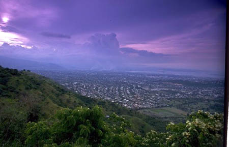
Holy Idaho! We are posting this blog from our smartphone. Hopefully, we will be able to get better reception soon! Right now, we have a bigger problem. The helicopter Louie sent to take us away has dropped us off on the TOP of a random mountain! We have no idea where we could be. Too bad the phone's GPS is not working! Louie is obviously trying to get rid of us and does not trust us at ALL, somehow because of Mike the hiker. I am digging through my backpack, looking for something to use to get help! We have no idea where we are! Geo has an idea we are going to try. We are going to try using the old gum wrapper that was wadded up in the bottom of Geo's backpack. Do you remember we got the gum from the guy in Washington, D.C.? We are going to try to reflect the sun with the gum wrapper to get an aircraft's attention--if one ever flies by! I have no idea why Geo would save a wrapper, but I am glad that he did!!! I hope his plan works. While we wait for someone to fly over, we are hiking across the mountain and then following where the water runs downhill. Geo figures, if we follow the flow of water, we will eventually be in civilization. Hopefully, this plan will work!
- Meri
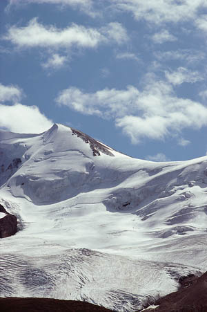
Here is the view from where we are located (sent via smart phone). Any ideas?
Tuesday
Guess what! My plan actually worked. After a few hours of hiking (which was very cold), we finally had a large plane fly by. I tried to use the sun's reflection off the wrapper to get the pilot's attention, but it didn't work. Then another plane flew by, and we missed it again! But the third one (a private plane, flying lower) saw us (and our gum wrapper) and flew back around so we know he saw us. There wasn't enough room to land their plane, but they called in our exact longitude and latitude to the state police. A rescue snowmobile came and picked us up about an hour later. The plane flew around overhead until the rescue snowmobile arrived. We had no idea who was coming, but we KNEW someone would help us. We are glad to be safe and back on our real laptop again instead of typing into that tiny phone. Can you guess where we could be that they have snowmobiles to pick us up?
You are probably wondering what longitude and latitude mean. Maps have these imaginary lines to help us figure out exact locations of places. (You can't actually see them printed on the Earth or anything.). Here is the lowdown on these lines. The lines that run up and down the map (north and south) are called longitude lines. These lines are used to measure degrees east or west from the prime meridian. The prime meridian is located at 0 degrees longitude. The prime meridian is an imaginary line that runs up and down through the United Kingdom, France, Spain, western Africa, and Antarctica. Do you have any idea where those countries are located? The prime meridian divides the world into the eastern hemisphere and western hemisphere. (Hemisphere means half of a sphere). The lines that run across a map (east and west) are called latitude lines. Lines of latitude measure degrees north or south. The equator is at 0 degrees latitude. This imaginary line marks halfway between the North Pole and the South Pole. The equator runs though parts of Asia, South America, and Africa. This imaginary line also divides the world into the southern hemisphere and northern hemisphere. Do you know if the United States is in the southern hemisphere or the northern hemisphere? Longitude and latitude are both used to measure distance in "degrees". I am still trying to think of a way to tell the two kinds apart. Wow, Meri just taught me an easy way to remember the directions of the lines. Think of latitude as a "ladder" (kind of sounds similar). The steps of a ladder go up and down just like the lines of latitude go on the map. I put some pictures in my blog to better explain this confusing geography stuff. Both lines (latitude and longitude) start at 0. These lines are drawn only on maps and globes. So, don't expect to see an "equator line" on the streets and beaches of Brazil! I wonder how longitude and latitude help us -- or why they are even used? Meri explained that the purpose of longitude and latitude is to help identify your specific location on the earth's surface. Thankfully the pilot of the jet thought to provide our exact longitude and latitude! Uncle GT also emailed me this neat picture of a globe/map (it really helped me to understand what all of those lines represent). See my pictures, below.
You are probably wondering what longitude and latitude mean. Maps have these imaginary lines to help us figure out exact locations of places. (You can't actually see them printed on the Earth or anything.). Here is the lowdown on these lines. The lines that run up and down the map (north and south) are called longitude lines. These lines are used to measure degrees east or west from the prime meridian. The prime meridian is located at 0 degrees longitude. The prime meridian is an imaginary line that runs up and down through the United Kingdom, France, Spain, western Africa, and Antarctica. Do you have any idea where those countries are located? The prime meridian divides the world into the eastern hemisphere and western hemisphere. (Hemisphere means half of a sphere). The lines that run across a map (east and west) are called latitude lines. Lines of latitude measure degrees north or south. The equator is at 0 degrees latitude. This imaginary line marks halfway between the North Pole and the South Pole. The equator runs though parts of Asia, South America, and Africa. This imaginary line also divides the world into the southern hemisphere and northern hemisphere. Do you know if the United States is in the southern hemisphere or the northern hemisphere? Longitude and latitude are both used to measure distance in "degrees". I am still trying to think of a way to tell the two kinds apart. Wow, Meri just taught me an easy way to remember the directions of the lines. Think of latitude as a "ladder" (kind of sounds similar). The steps of a ladder go up and down just like the lines of latitude go on the map. I put some pictures in my blog to better explain this confusing geography stuff. Both lines (latitude and longitude) start at 0. These lines are drawn only on maps and globes. So, don't expect to see an "equator line" on the streets and beaches of Brazil! I wonder how longitude and latitude help us -- or why they are even used? Meri explained that the purpose of longitude and latitude is to help identify your specific location on the earth's surface. Thankfully the pilot of the jet thought to provide our exact longitude and latitude! Uncle GT also emailed me this neat picture of a globe/map (it really helped me to understand what all of those lines represent). See my pictures, below.
- Geo
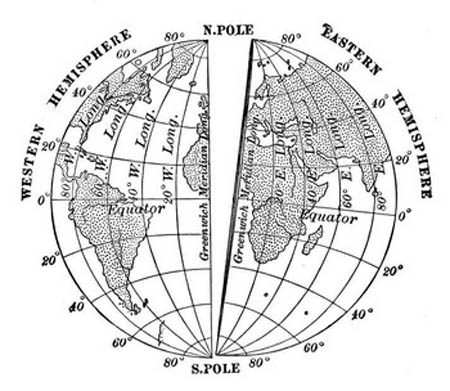
This picture shows the prime meridian, equator, eastern and western hemispheres, lines of latitude, and lines of longitude.
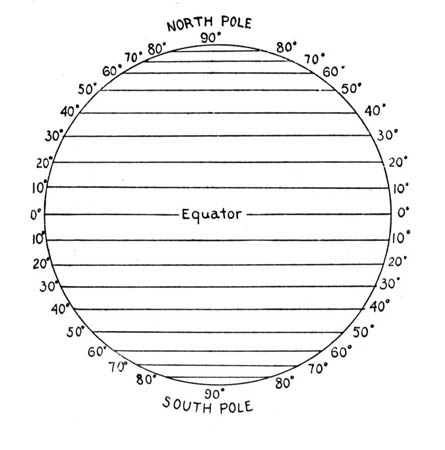
This picture shows the lines of latitude. Do you see the equator? The lines of latitude run across a map, but they measure degrees north and south from the equator. The lines of latitude are like the steps of a ladder on the globe.
Wednesday
Last night we finally figured out where we are: the Rocky Mountains. The rescuers were so busy getting us warm, they never really told us our location. We are now in a warm hotel right outside of Denver. Denver is in the state of Colorado. We included a map of Colorado in this blog entry. Holy Idaho was Monday ever cold! Did you know that Denver was nicknamed the Mile-High City? This is because the elevation of the city is exactly a mile (5,280 feet or about 1,609 meters) above sea level. I wonder if there are any cities in the world higher than Denver.
Another interesting fact about Denver is that it is one of the few cities in history that was not built on a railroad, road, lake, or another body of water when it was founded. They found a few flakes of gold there in 1858, and Denver was "born."
Denver has a semi-arid climate and experiences all four seasons. Denver has a lot of sunshine though. I read that Denver receives over 300 sunny days each year! Wow, nearly every day is sunny! The state of Colorado is 380 miles long and 280 miles wide. I guess it is in the shape of a rectangle. Another interesting fact that I learned is that even though Colorado has the beautiful Rocky Mountains, the eastern 2/5 of the state is very flat and has no mountains. Wow - Colorado is such an interesting state. Now, do you think Louie is somewhere here? What should we do next? We have no clues to follow?
- Meri
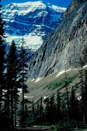
Another view of the beautiful Rockies!
A unique picture we found of Denver, Colorado.
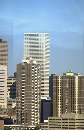
Downtown Denver
Interactive Map of Colorado
Take a look at this map. You may need to navigate a bit. Can you find Denver? What cardinal direction would you travel going from Denver to Colorado Springs? What other large cities can you find in Colorado?
Vote Here:
102
Copyright © 2011-2024 by The Source for Learning, Inc. All rights reserved.